
Understanding Geographic Coordinate Shifting: 10 Meters Left and Right
Geographic coordinate systems are essential for mapping and analyzing spatial data. Whether you're working on environmental studies, urban planning, or any geographic information system (GIS) application, understanding how to manipulate and calibrate coordinates is crucial. In this blog post, we’ll explore how to shift coordinates by 10 meters to the left (west) and right (east), and why this might be necessary in various fields.
What is Coordinate Shifting?
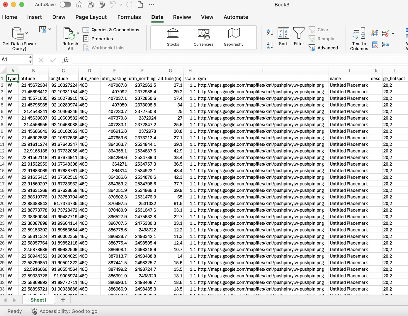
Coordinate shifting involves adjusting the geographic coordinates of a point (latitude and longitude) to account for changes in position. This is particularly useful when dealing with measurement errors, aligning data from different sources, or adjusting for specific real-world applications such as mapping or surveying.
Why Shift Coordinates?
There are several reasons for shifting coordinates:
- Error Correction: Measurement inaccuracies can lead to slight deviations in recorded coordinates. Shifting helps correct these errors.
- Data Alignment: When combining datasets from different sources, aligning coordinates can ensure consistency.
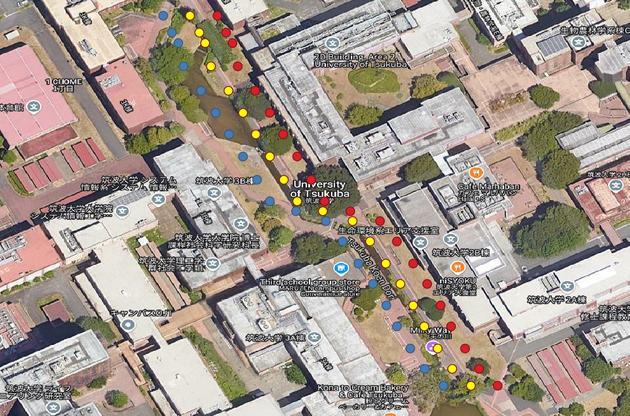
- Real-World Applications: In fields like agriculture, forestry, and urban planning, small adjustments in coordinates can significantly impact outcomes and analyses.
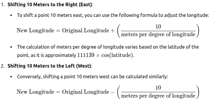
Calculating a 10-Meter Shift
To illustrate how to shift coordinates, we can use a simple method that calculates the change in longitude based on the latitude of the point. Here, we will shift coordinates 10 meters to the left (west) and right (east).
Practical Implementation with Python
Using Python, we can implement these calculations to shift coordinates. Below are two example scripts: one for shifting 10 meters to the right and another for shifting 10 meters to the left.
Shift Coordinates to the Right
import math
import pandas as pd

# Constants
METERS_PER_DEGREE_LATITUDE = 111139  # Approximate meters per degree of latitude

# Function to calculate the new longitude shifted 1 meter to the right
def shift_longitude(lon, lat, distance_meters):
    # Calculate the distance per degree of longitude based on the latitude
    meters_per_degree_longitude = METERS_PER_DEGREE_LATITUDE * math.cos(math.radians(lat))

    # Calculate the change in longitude for the given distance
    delta_lon = distance_meters / meters_per_degree_longitude

    # Return the new longitude shifted by delta_lon
    return lon + delta_lon

# Read CSV input
input_file = '/media/manik/PERSONAL/Essential_Scripts/ShiftedCoordinates/input_lat_lon.csv'
df = pd.read_csv(input_file)

# Using the correct column names from your file
lat_lon_data = df[['longitude', 'latitude']].values

# Calculate the shifted longitudes
shifted_coordinates = [(lat, lon, shift_longitude(lon, lat, 10)) for lon, lat in lat_lon_data]

# Create a DataFrame for output
df_shifted = pd.DataFrame(shifted_coordinates, columns=['Latitude', 'Original Longitude', 'Shifted Longitude (1m right)'])

# Save the result to a new CSV file
output_file = '/media/manik/PERSONAL/Essential_Scripts/ShiftedCoordinates/shifted_lat_lon10.csv'
df_shifted.to_csv(output_file, index=False)

# Confirm output file path
output_file
Shift Coordinates to the Left
import math
import pandas as pd

# Constants
METERS_PER_DEGREE_LATITUDE = 111139  # Approximate meters per degree of latitude

# Function to calculate the new longitude shifted a specified distance to the left
def shift_longitude_left(lon, lat, distance_meters):
    # Calculate the distance per degree of longitude based on the latitude
    meters_per_degree_longitude = METERS_PER_DEGREE_LATITUDE * math.cos(math.radians(lat))

    # Calculate the change in longitude for the given distance
    delta_lon = distance_meters / meters_per_degree_longitude

    # Return the new longitude shifted by delta_lon (subtract for left shift)
    return lon - delta_lon

# Read CSV input
input_file = '/media/manik/PERSONAL/Essential_Scripts/ShiftedCoordinates/input_lat_lon.csv'
df = pd.read_csv(input_file)

# Using the correct column names from your file
lat_lon_data = df[['longitude', 'latitude']].values

# Calculate the shifted longitudes for 10 meters to the left
shifted_coordinates = [(lat, lon, shift_longitude_left(lon, lat, 10)) for lon, lat in lat_lon_data]

# Create a DataFrame for output
df_shifted = pd.DataFrame(shifted_coordinates, columns=['Latitude', 'Original Longitude', 'Shifted Longitude (10m left)'])

# Save the result to a new CSV file
output_file = '/media/manik/PERSONAL/Essential_Scripts/ShiftedCoordinates/shifted_lat_lon_left.csv'
df_shifted.to_csv(output_file, index=False)

# Confirm output file path
output_file
Conclusion
Shifting geographic coordinates is a straightforward yet powerful tool in geospatial analysis. Whether you're correcting errors, aligning datasets, or conducting precise analyses in the field, understanding how to shift coordinates accurately is invaluable. By using simple mathematical formulas and Python scripts, you can enhance your geographic data's accuracy and utility.
If you have any questions about coordinate shifting or how to implement these concepts in your projects, feel free to leave a comment below!


0% Positive Review (0 Comments)